Actual original post seems to have been moved/removed, but: http://planets-bend-between-us.tumblr.com/post/18591993325/nasa-recently-released-imagery-showing-the
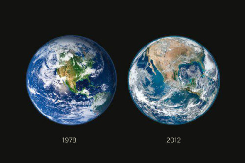
"NASA recently released imagery showing the deforestation of America …in just 34 years."
hmm.
edit: By "hmm" I meant "hmm, I dunno about that" (this icon on DW is one of my "o rly?"/skeptical icons; that didn't come over on LJ). It looked to me more like dry and wet seasons or some such thing and according to this link from![[personal profile]](https://www.dreamwidth.org/img/silk/identity/user.png) jarandhel it looks like I may have had the right idea there.
jarandhel it looks like I may have had the right idea there.
"NASA recently released imagery showing the deforestation of America …in just 34 years."
hmm.
edit: By "hmm" I meant "hmm, I dunno about that" (this icon on DW is one of my "o rly?"/skeptical icons; that didn't come over on LJ). It looked to me more like dry and wet seasons or some such thing and according to this link from
no subject
Date: Mar. 6th, 2012 11:15 pm (UTC)From:no subject
Date: Mar. 6th, 2012 11:43 pm (UTC)From:no subject
Date: Mar. 7th, 2012 12:42 am (UTC)From:no subject
Date: Mar. 7th, 2012 12:58 am (UTC)From:I've been reading How To Lie With Maps and Making Maps and stuff, and this is the kind of picture that they would use in there to demonstrate how maps, even ones that partially use satellite imagery, are never literal truth.
no subject
Date: Mar. 6th, 2012 10:22 pm (UTC)From:no subject
Date: Mar. 6th, 2012 11:13 pm (UTC)From:no subject
Date: Mar. 6th, 2012 11:21 pm (UTC)From: